JAMES MADISON QUOTE - 1822

"A popular government without popular information, or the means of acquiring it, is but a Prologue to a Farce or a Tragedy; or, perhaps both. Knowledge will forever govern ignorance; and a people who mean to be their own governors must arm themselves with the power knowledge gives."

SCOTTSBORO WEATHER - SUN & MOON RISE

Showing posts with label tornado. Show all posts

Monday, January 24, 2022

January 24, 2022 Scottsboro, Alabama - Flawed State of Alabama Hazard Mitigation Plan, Tornadoes and GE Mark 1 Nuclear Reactors, Reported to Emergency Management Agency, FEMA and TARCOG - UPDATE - Jan. 25, 2022 - Reply From TARCOG/FEMA


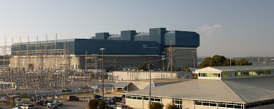
TVA Browns Ferry Nuclear Facility near Tanner, Alabama TVA info: Browns Ferry Nuclear Plant (tva.com) Photo by TVA a US Government corporate entity. Fair Use for non-profit news reporting, education and commentary. 

13 years reporting on the GE Mark 1 Reactors, The TVA Browns Ferry Nuclear Facility saga:   https://arklite.blogspot.com/search/label/TVA%20Browns%20Ferry

FLAWED STATE OF ALABAMA HAZARD MITIGATION PLAN INVOLVING TORNADO THREATS AND THE BROWNS FERRY NUCLEAR FACILITY, A 3 UNIT GE MARK 1 NUCLEAR FACILITY

REPORT TO FEMA AND TARCOG


My name is Garry L. Morgan, U.S Army Medical Department Retired, member of the Blue Ridge Environmental Defense League, BREDL and BEST, Bellefonte Efficiency and Sustainability Team. - I am providing feedback regarding a failure to identify a specific hazard, severe tornado threat to the Browns Ferry Nuclear Facility, near Tanner, Alabama, Limestone County, in the Hazard Mitigation Plan, Division F involving North Alabama, and request this failure to identify the significant hazard be corrected. Info below.

There is a serious deficit regarding Hazard Profile Section 4, Division F in regards to Tornado Activity and the TVA's Browns Ferry Nuclear Plant (BFN). A near miss occurred on April 27, 2011 in Limestone County. The F-5 tornado took out incoming power to the nuclear reactors, there was one backup generator failure. --- BFN is a GE Mark 1 Reactor design, there are no hardened overhead secondary containments covering the 3 GE Mark 1 Reactors and fuel pools at BFN. The overhead area is sheet metal attached to steel I beams. --- The area experienced no electrical power for an extended period, some areas were without power in excess of 5 days. --- A direct hit of the reactor building by an EF4-5 tornado would likely be a catastrophic event involving all of North Alabama and portions of South Tennessee. A release of radioactive material in the immediate area and downwind would be a high probability. --- TVA's, Tennessee Valley Authority, and NRC's, Nuclear Regulatory Commission, assessment of the event was unreliable, and their reporting accuracy to the public was flawed. ( News Reports of flawed assessments, as reported by nuclear industry specialists: Browns Ferry: Shrinking the safety margin at Alabama's largest nuclear plant - al.com link: https://www.al.com/wire/2013/07/browns_ferry.html  note the sheet metal coverings over the nuclear fuel pool in the photos within the article listed;  and TVA resuming power generation at Browns Ferry nuclear plant - al.com link: https://www.al.com/breaking/2011/05/tva_to_resume_power_generation.html note-there was an emergency generator failure which TVA did not disclose to the public.) --- Failure to include tornado events and mitigation regarding BFN is an error which must be corrected.

Regards,
Garry L. Morgan, USAMEDD Retired
BREDL/BEST  
(contact info redacted, submitted in original document)

April 27, 2011 Tornado Tracks
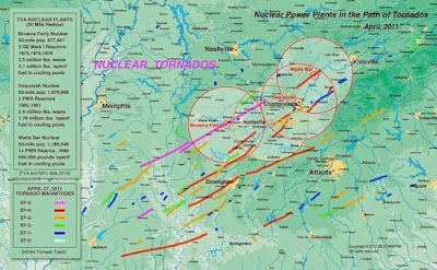
BEST/MATRR Tornado Track Map, 4/27/2011 - Fair Use for education, news reporting and commentary. 

Reply From TARCOG/FEMA

Thank you so much for providing us with this critical information.

We certainly did not intent to leave this particular event out of the regional document.
While we have noted other tornadic events throughout the region, it seems this one was not reported to NOAA as specifically having impacted the Browns Ferry Nuclear Plant (BFN).

It also appears that finding this information would have been a bit difficult, as your note states that certain segments of the event were not published to the public.

Are there any additional events that we need to be made aware of regarding any other facilities?
If so, please pass along that information as well.

We thank you again for giving us this evidence and we assure you this event will be added to the regional mitigation document.
(original email document signed)


Tuesday, November 6, 2018

Aspel, Alabama November 6, 2018 Tornado Damage Videos, Photographs, Line Path of Damage Photo

Aspel Tornado Path Map - Over 100 Residents in area without power for more than 12 hours, loss of income for business, property damage and food spoilage damage, maybe over $300,000. (Google Maps - Fair Use for non-profit news reporting, path and construct of map by G. Morgan)
(Click on any image to enlarge view.)

Aspel twisted sign (photo by G. Morgan)

F-1 Tornado Evidence Aspel Tornado (photo by G. Morgan)

Aspel Tornado damage, F-1 (photo by G. Morgan)

National Weather Service Link on Fujita Scale

VIDEOS Aspel Tornado Damage
Part 1


                                              Part 2

Wednesday, April 6, 2016

Scottsboro City Council Work Session - A Question of Priorities - Financial Info Regarding City Capital Projects - Raymond James Financial $2.83 Million Payback for $3 Million in Bonds?? First Monday Weekend, "Cruz'n the 'Boro"

Scottsboro City Hall (photo by G. Morgan)

AGENDA
Click on agenda for an expanded view.

Special Video - Segments from Raymond James Financial Services on proposed bond issue. Mayors comments on project dates, Council Member Smith and Wallingsford expresses concerns and ask important questions.


Recent photo of tornado taken from roof of Highlands Medical Center. (photo WHNT-TV Fair Use for non-profit News Reporting.)

There seems to be a question of priorities regarding spending of money. There is not one shelter in Scottsboro built by the City of Scottsboro. The Jackson Coiunty Courthouse is the only approved shelter; this leaves areas west, east and south in the City of Scottsboro without sufficient storm shelters. There are large mobile home communities in these areas.

HIGH RISK CORRIDOR - New Research of the increased frequencies of Tornado Activity in the Tennessee River Valley. http://blog.al.com/breaking/2013/09/birmingham_huntsville_part_of.html
(Fair Use rights for non-profit news reporting.)
Analysis in a research paper co-authored by a researcher at UAH showing the average annual path length (in km) of all significant (F2-F5) tornadoes passing within 40 km (25 miles) of a point between 1973 and 2011. The research graphic demonstrates that the Deep South has emerged as the nation's new tornado alley. (Coleman & Dixon research/American Meteorological Society).

Full City Council Meeting Video


First Monday Trade Days Weekend - Saturday Scottsboro Cruz'n


                            SCOTTSBORO BBQ COOKOFF

Saturday, April 4, 2015

Removed from the Jackson County Courthouse During a Tornado Warning - Pets Not Allowed - Citizens Not Informed

BeBe

A report on my experience at the Jackson County Court House during the tornado warnings this evening, April 3, 2015, approximately 8:30-9:00PM. There were two radar reported tornadoes during this time frame on or near the Jackson-Madison County Line. My Weather Underground Radar subscription indicated one tornado near the Jackson - Madison County line near Gurley. At that point I left to go to the nearest storm shelter, the Jackson County Court House.

Unfortunately some folks employed by Jackson County do not realize the importance of pets to people in storms. I was removed from the Jackson County Court House this evening during the tornado warnings because I brought my pet with me. Never before had this been a problem with pets in the court house during storms.

Mr. Felix Jackson, EMA Representative stated I must remove my dog, my reply, “I would not leave until the storm was over.” Jackson informed me, “I could stay but the dog had to go because of insurance reasons.” Again he was informed, “I would leave as soon as the storm was over.” (BeBe, my dog, was in a harness and on a leash, very quiet and much behaved.) His reply, "the dog must go but you may stay," My reply, "no, I'm not leaving unless you get the Sheriff’s Department to make me leave," and he did. If I must remove my dog, I would not have been present in the shelter.

Mr. Jackson left for a few minutes and returned with two Sheriff’s Deputies, one Lieutenant and one Sargent. On that note, Mr. Jackson informed me, "the dog must go, but you may stay." Again I stated, "I'll leave as soon as the storm is over," again Jackson stated, "the dog cannot stay." I was not going to put my dog out into the storm, BeBe was given to me by my wife before she passed away. No way was I going to treat my beloved pet in such a fashion

The answer would have been to say this - "Mr. Morgan, dogs are no longer allowed in the Court House, as soon as the storm is over please take your dog out and remember that you may not bring your dog into the court house unless it is a service dog." When I left I informed Mr. Jackson, with the two Sheriff's Deputies present, "you have not heard the end of this." Mr. Jackson replied, "You know where I'm at."

There are no signs posted at any entrance or exit at the Jackson County Court House that pets, during a storm, are not allowed.

I've attended 99% of regular commission meetings where decisions are made by vote, and never has there been any notice or information placed into the public view or discussion during any meeting about no pets in the court house storm shelter. BeBe has been with me on several occasions in the court house to take shelter from inclement weather. Never has there been a problem until this evening, when BeBe and I were put out into the storm.

Update: April 4, 2015 - 4:00PM I have been informed by Face Book message by those present witnessing the incident in the courthouse storm shelter, there was at least one other small dog present and Mr. Jackson went straight for me immediately after my arrival. Within 5 minutes of my arrival Mr. Jackson was asking me to remove my dog. 

Discussing this incident with retired law enforcement, there is a question whether there is a law affecting Jackson County which prohibits pets from public storm shelters in Jackson County. 

Today there is a printer originated notice on the door of the storm shelter entrance that says, "No Pets Allowed." I saw no such notice last night posted on the door to the shelter entrance. When was there a county commission resolution passed stating this policy? After review of video and agendas for the past 3 years I can find no such policy approved by the Jackson County Commission. County Animal Control Ordinance passed by resolution contradicts the actions taken by officials of Jackson County.  

As it turns out, pets in shelters is a national problem, there is an answer, "pet carriers."

Tuesday, May 3, 2011

Videos of the April 27, 2011 Tornadoes - You Tube

"Tornado on Sand Mountain near Henegar, Ider, Pisgah. Film was taken from Mentone, AL on Lookout Mountain at 4:47pm. by scout58"


"Videos taken on April 29 and 30, 2011 in Rainsville, Sylvania, and Henagar, Ala. Music: The Valley Song - Jars of Clay Videography: Devin & Lane by AlabamaLlama"


"Rainsville Alabama EF4 Tornado April 27 2011, uploaded by pitwagonweb. This was shot from the front of our office at 61 main street east in Rainsville Alabama along AL Hwy 35 near the intersection of AL Hwy 75"


National Weather Service Map: http://www.srh.noaa.gov/srh/ssd/mapping/

WHNT-TV storm track map link: http://www.whnt.com/weather/stormcentral/wdaf-google-maps-show-tornado-reports-storm-tracks-satellite-images-of-destruction-20110501,0,6686199.htmlstory

Tornado Casualty list link: http://blog.al.com/wire/2011/04/alabama_tornado_casualties_a_l.html


Monday, October 25, 2010

Severe Weather in Jackson County, Failed Warning System

Local storm track at 3:40-3:45 AM, circles indicate damage to homes or structures. A indicates Rosalie, Al. Click on maps or photos for expanded view.
Northeast Alabama storm Track from Cullman, Morgan County to Jackson County, Al.. At approximately 3:15 it was reported that a tornado was on the ground at Columbus City near grant.

Damage near Pleasant View Community, State Hwy 40 & co Rd 22.


Approximately 4:00AM, Oct. 25, 2010 Jackson County experienced severe weather, tornado vortex signature and damage indicates an F-0 or F-1 tornado.

National Weather Service issued Tornado Warnings as early as 2:30AM for Morgan County, tornado warnings were issued at approximately 3:15 for Marshall Co. and Jackson Co. at 3:45. It was obvious that the line of storms was going to involve Jackson County at 2:45 AM. Unfortunately our EMA did not react nor was there a sufficient warning issued. Prior conversations with the Jackson County EMA officials reveal that due to the fear of legal action warnings will not be issued until the National Weather Service issues a specific warning for the area. Here we have bureaucrats making decisions of life and death based on a fear of legal action not decisions based on good sense and science. Bureaucratic Protocol takes precedent over good sense, science and the issuance of life saving, timely severe weather warnings.

From 3:45 till 4:10 AM Jackson County experienced severe weather destroying property, down trees and power lines on Sand Mountain between Rosalie and Henager. Damage was also reported near Section. A tornado was reported on the ground at Columbus City near Grant, Al.

911 reported calls from many citizens of the area reporting they were attempting to gain access to area public shelters, however those shelters were closed. The emergency warning system did not sound in Scottsboro although a tornado warning was issued.

The area around Co Rd. 422 off of State Rd. 40 reported severe damage, per 911 communications; area around Pleasant View also reporting damage.

First Responders and road crews were out early cleaning up the blocked roads and checking for damage and entrapment. Mutual assistance call has gone out due to severe damage on Sand Mt. State Hwy. 40 area. A tornado was reported in that area (see photos above).

Tuesday, February 19, 2008

Protocol vs Life Saving Tornado Warnings or Money vs Life


In the early morning hours of February the 6th, 2008 an EF4 tornado, according to the National Weather Service, touched down in Jackson County. I was up and tracking the storm from the point it demonstrated a Tornado Vortex Signature approximately 60 miles southwest of Scottsboro until the storm was immediately west of Guntersville. At that point the Weather Underground site demonstrated the storm would either hit Scottsboro or Sand Mountain. Either way I decided it was time to leave my home and go to the nearest shelter, which was the Jackson County Courthouse. I sat in my car for a few moments and waited for an audible warning over WKEA radio. It was pouring rain and the wind was blowing hard. The first audible official warning was sounded on the radio between 5:05 and 5:10. I immediately went inside the Courthouse basement. By this time the storm was already in Jackson County. My previous tracking of the storm over Weather Underground and Monitoring of all TV stations indicated the storm was moving at 55-65 mph. The storm was already in Jackson County before the warning was given. I did not hear the warning sirens in Scottsboro at 5:05. A friend of mine near the Dutton Community told me he heard the first official warning at 5:10 and they headed to his storm shelter. He stated to me he could hear the warning sirens as they proceeded to take shelter. The tornado struck the Pisgah-Rosalie area at 5:15AM.


I have been performing extensive research on National Weather Service (NWS) tornado warning protocol. I found this disturbing information: http://ams.confex.com/ams/pdfpapers/120818.pdf This paper indicates the NWS is more concerned over savings of money in sheltering people rather than saving life. The disturbing paragraph reads as follows:
"As cited earlier, a NWS demonstration test in 2005
showed reduction in the area warned at near 70%. A
recent scientific study by University of Oklahoma
Associate Professor of Economics Dan Sutter (now
associated with University of Texas – Pan American)
concluded that a reduction of 70% of the area warned
would minimally save the economy hundreds of millions
of dollars in reduced cost of sheltering (Sutter, 2006)."


This individual storm warning protocol has been sold to citizens as a measure to advance the warning of life threatening storms. I can distinctly remember local weather news broadcasts indicating this fact. If the system is applied properly it will do exactly that, a superior advanced storm warning for specific areas. However, this is not the case, it appears the system and the bureaucrats running it prefer to utilize the system, as the article indicates, to save money NOT LIVES. The February 6, 2008 official storm warning was not given until the storm was well into Jackson County. This defeats the purpose of a comprehensive warning system.


It is my belief that the NWS and the County's EMA warning system is hindered by bureaucratic protocol. Kudos should go out to the local TV stations and their staffs. They did a wonderful job warning the public of this storm and saved lives. The Weather Underground web site is another wonderful tool in storm warnings. (This site is linked in my links section.) No home should be without a weather warning radio, properly programmed and turned on.


I wondered why the NWS and EMA did not issue a timely warning, now I know the reason, bureaucratic protocol placed over life saving measures. It is my belief this damning article proves the point, along with eyewitness testimony of the actual warning. (photo credits: public domain money stack photo; tornado n' lightning: http://wallpapers.jurko.net/pic/1130/ ; Rosalie Damage photo, courtesy: Creig Moore
Addition, 2/20/2008: The Jackson County EMA does not initiate siren "warnings" for Scottsboro. Scottsboro does not have any warning sirens as of this date. After discussions with Victor Manning, Director Jackson County EMA, it has been revealed that the EMA issued 3 tornado warnings after the National Weather Service initiated the warnings. Times of the warnings were not recorded.